Chile doesn’t always make it to the top of traveler’s itineraries. Travel costs and a more European culture compared with other South American countries have diminished its appeal.
But those who give it a chance learn something that the thriftier travelers don’t: Chile is stunning. And the best place? Patagonia’s Carretera Austral.
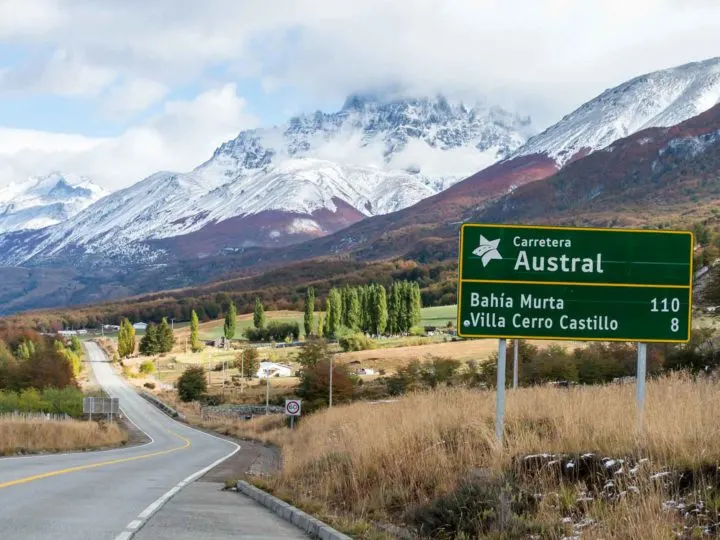
The Carretera Austral road trip: a true Patagonian adventure
When I first arrived in Patagonia back in March 2016, it was in the back of a purpose-built overlanding truck.
Little did I know that this was the start of a love affair that would see me spending the next three years visiting the length and breadth of Chile. Its diverse natural beauty and welcoming culture saw me falling head over my walking boots in love.

Before I got to Patagonia, I had been struck by the adventurous possibilities of the vast deserts and salt flats of the Atacama Desert in the north and the vineyards and snow-topped mountains crisscrossed with ski runs that surround Santiago.
But then I stumbled upon the Carretera Austral.
Found my advice helpful and want to say thanks?
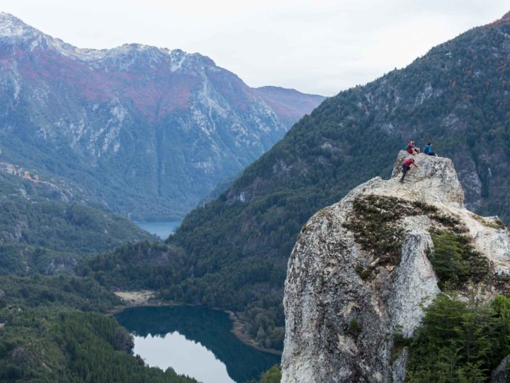
Why I love Chilean Patagonia’s Carretera Austral
I’ve since returned practically every year to explore even further and deeper into what is northern Chilean Patagonia’s only highway.
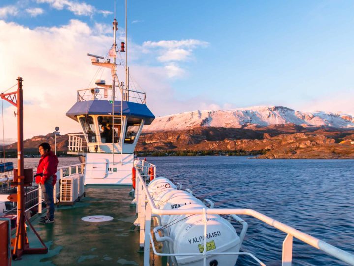
I’ve taken almost all of the ferries that you can to get here. I’ve travelled by bus and car; I’ve hitchhiked and even gone on foot along stretches of this famed highway.
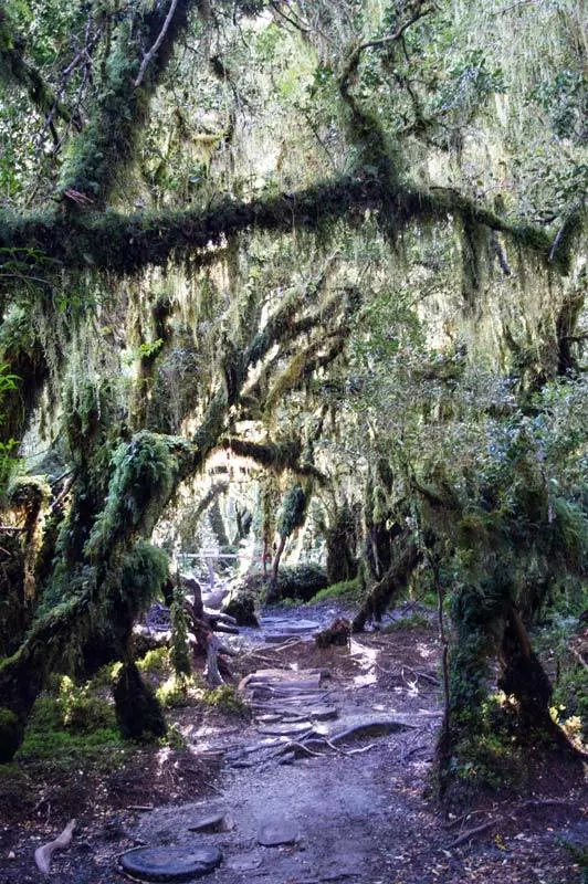
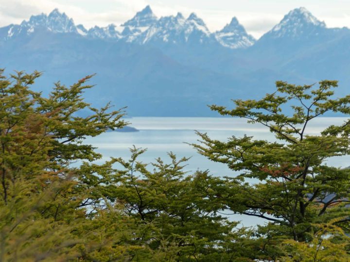
I’ve trekked into the rugged depths of its various national parks, climbed to lofty viewpoints above sweeping landscapes of lush temperate rainforests, sat in the spray of powerful waterfalls and stood in awe beneath egg-blue glaciers that seem to tumble from cliffsides as you watch.
For me, the Carretera Austral is the pinnacle of why Patagonia holds its travellers in an indescribable awe. It beats the allure of Torres del Paine National Park in the south and is packed with enough glaciers and pristine lakes to give the Perito Moreno glacier and Parque Nacional Los Glaciares in Argentina a run for their money. It’s one of my favorite places – and contains some of the best destinations to visit in Patagonia (and Chile in general!).

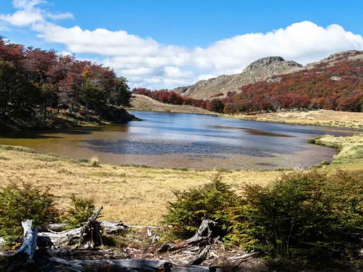
What you can expect to discover here are endless opportunities for camping and trekking, appreciating nature at its most remote and untouched and being fortunate enough to experience Patagonia’s – and perhaps South America’s – most incredible road trip.
What, and where is the Carretera Austral?
The Carretera Austral (which means “Southern Highway”) refers to the 1,240-kilometer (770-mile) road that runs from Puerto Montt to Villa O’Higgins all the way through northern Chilean Patagonia.
Also known as Ruta 7 (“Route 7”) or the “Ruta Austral” (the “Southern Route”), this road connects its northernmost point, Puerto Montt (in the Chilean Lakes District), and its southernmost point, Villa O’Higgins (in the Aysén region).
It spans a territory that is divided from Argentina in the east by the Andes Mountains and bookended in the west with the narrow channels and fjords of the Pacific Ocean.
What makes it so captivating a destination to visit is the fact that the Carretera Austral remains the only road connecting Puerto Montt and the deep, remote regions of Northern Patagonia.
This region is among the least inhabited in Chile, with – on average – fewer than one person per square kilometer living here.
What you’ll quickly realise is that this lack of habitation is evidenced in other ways: namely through the state of the road.
Don’t be fooled: the name The Southern Highway disguises the fact that the Carretera Austral remains a work in progress, with vast tracts of the road still unpaved.
And why is it so famous?
It’s partly because of its poor state that the Carretera Austral has reached such elevated status in travellers’ imaginations. Unpaved, pot holed and impassable due to the elements: all of these are qualities have helped secure the Carretera Austral as one of South America’s most remote – and therefore most beguiling – road trips.
Another feature of the road’s infamy is the fact that it was one of the main infrastructure legacies of the Pinochet dictatorship (which also killed and “disappeared” over 40,000 people).

Prior to the 1980s, this part of Patagonia was practically unconnected from outside civilisation, with no roads linking the majority of the settlements that were beginning to grow.
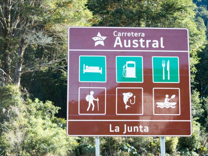
Construction of the road took twenty years and locals still refer to it as “Pinochet’s Highway”. You can even find a monument to the dictator in La Junta.
The Carretera Austral is also part of the brand new Ruta de los Parques, an initiative stretching 2,735 kilometres from Puerto Montt to the very tip of Patagonia at Cape Horn that aims to join up 17 Chilean national parks.
Although international press has reported it as such, this is not a contiguous hiking route. Instead, the Route of the Parks is a marketing exercise to showcase the wealth of nature that Chilean Patagonia contains.


If you want to explore it, the Carretera Austral is an excellent place to start: 10 of the 17 national parks are located here and the majority are accessible by car or bus with day and multi-day hikes awaiting.
Know-before-you-go facts about the Carretera Austral
Listen to me talking about the Carretera Austral
In September 2020, I joined Chris from The Amateur Traveler discussing my favourite itineraries and destinations along the Carretera Austral. You can listen to the episode here.
Unmissable sights along the Carretera Austral, Chile
When I first arrived in Chile in 2016, I didn’t make it all the way down to Villa O’Higgins. From Puerto Montt, I took the Navimag Ferry to Puerto Chacabuco and headed directly to Coyhaique (unfortunately this ferry no longer operates), from where I boarded a bus to Rio Tranquilo further south to begin my trip.
Since then I’ve been back to explore the full length of the Carretera Austral, starting in Caleta Tortel and Villa O’Higgins in the south and gradually making my way up north to Puerto Montt. Altogether, I’ve spent at least two or three months in the region (most recently for my research for the Moon Chile guidebook).
From these glorious days of road-tripping, hitchhiking, camping, walking, and taking a boat and bus or two along this stretch, I’ve put together this list of the absolutely unmissable places to visit along the Carretera Austral.
Anything missing? Let me know in the comments below about your suggestions for where to travel in Chile and Patagonia and check out my fully comprehensive guide to planning your trip to Patagonia for information about the rest of the region.
Puerto Montt
Puerto Montt lies around two-thirds of the way down Chile’s epic 4,270 km coastline. It isn’t officially along the Carretera Austral, but it does mark the very northern tip of the road. As such, many travelers – whether they’re hoping to explore the full length or only a portion – begin their journeys here.
This port city in itself is a little rough around the edges and with little to appreciate beyond the views of Volcán Osorno and Volcán Calbuco (which lie northeast) that you experience on a clear day.
However, it is home to an array of ferry boat journeys into Patagonia and beyond and is the main departure point for buses heading south.

Chaitén and Parque Nacional Pumalín Douglas Tompkins
- Distance south of Puerto Montt: 240 kilometers
- Distance north of Coyhaique: 421 kilometers
The largest town in the far north of the Carretera Austral is Chaitén. A dusty, five-street place of ramshackle wooden houses huddled inland from a wide bay, it’s the gateway to one of Patagonia’s finest national parks: Pumalín Douglas Tompkins.
One of two in the region that was set up by the late Doug Tompkins, founder of the adventure brand North Face, Pumalín National Park (free) is exactly what you pictured when you thought about hiking in Patagonia.
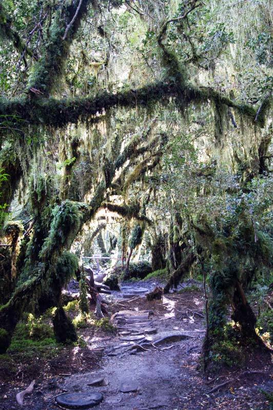
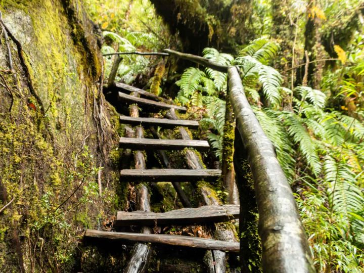
Here a multitude of picturesque campgrounds and trails have been established, the latter passing through lush Valdivian temperate rainforest to reach spellbinding lakes and waterfalls and towering, millennia-old Alerce trees.
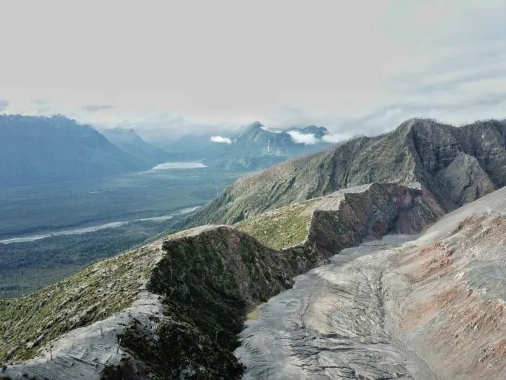
My personal favorite hike is the one leading up to the crater of Volcán Chaitén, a volcano that erupted in 2008 and laid waste to practically the entire town of Chaitén.
The views from the top, of both the surrounding countryside and the still-steaming peak and ragged crater, are equally incredible.
Pumalín Douglas Tompkins National Park is a fantastic spot to spend a few days, particularly if you’ve got your own camping gear, although you can stay in Chaitén and hitch a ride out to the park each day if you don’t.
Another option is in the pretty – but very expensive – cabins located in the very north of the national park.
Access from Chaitén is possible by hitching a ride, although bear in mind that some of the trailheads are a distance from one another (if you’re lucky, you should be able to catch another hitch to get between them).
You can also visit as part of a day trip (where you’ll hike to a number of the trails) with tour agencies based in Chaitén; I recommend local expert Nicolás La Penna of Chaitur Excursiones (expect to pay from $10,000 CLP pp ($14 USD)).

You can also get full information about the different trails and lodgings from the excellent Ruta de los Parques website (English).
Where to stay in Chaitén
Few lodgings are on sites such as Booking.com, so you’ll need to call or just turn up (and hope for the best!).
Where to stay in Chaitén: On the northern edge of town, but only a short, 10-min walk into Chaitén, Cabañas Los Canelos ($68,000 CLP, $73 USD) have pretty wooden cabins with huge windows, with some granted ocean views. There aren’t any kitchens, however cozy wooden stoves, WIFI, and a decent breakfast (CH$7,000) give these lodgings extra brownie points. Phone tel. 9/8188 2423 to make a reservation.
Where to stay on a budget in Chaitén: Hospedaje Don Carlos ($30,000 CLP ($41 USD) double) is a great choice. Their 23 rooms vary significantly in size; opt for the newer wing on the west of the house for substantially larger and superior rooms, all with private bathrooms and central heating. Rooms are plain but spotless, but wooden floors do mean you can sometimes hear your neighbors.

Getting to Chaitén
Taking the SOMARCO ferry from Hornopirén to Caleta Gonzalo: Both the first ferry from Hornopirén to Leptepu and from Fiordo Largo to Caleta Gonzalo is included in your ticket, which costs $44,300 CLP ($48 USD) per vehicle (includes driver) plus $7,400 CLP ($8 USD) per additional passenger. The boat leaves twice daily in summer but be sure to check their website for prices, and itineraries and to buy your tickets. In January and February make your vehicle bookings at least three weeks in advance. The first ferry (Hornopirén to Leptepu) has a cafeteria and seating area on board. You need to be at the terminal between two and three hours before departure, so make sure you give yourself plenty of time for the drive from Puerto Montt (including the first ferry). As of 2020, there is a new, direct ferry from Hornopirén to Caleta Gonazalo for dates in November through February only; full info in the drop-down above.
Futaleufú
- Distance south of Puerto Montt: 391 kilometers
- Distance north of Coyhaique: 422 kilometers
While not officially on the Carretera Austral, Futaleufú (aka Futa to the locals) is a charming town that merits a few days of detour.


Here you can pass hours hiking along trails for sublime mountain and lake views, partaking in world-class rafting or kayaking, or simply enjoying the peaceful ambiance of the laid-back town
Expert-level rafting on the Rio Futaleufú brings the crowds here during the summer, particularly as this is considered one of the best places in the world for this water sport. Kayaking along tributaries of the Futa river can also be arranged.
Plenty of companies lead tours; I would recommend Rafting Futaleufú. You’ll pay around $45,000 CLP ($50 USD) for a half-day tour.
Hiking trails are also numerous. One I did was the route up to Piedra LaAguila (Eagle Rock), where, via a series of rather steep but ultimately worthwhile switchbacks, the path reaches the spire-like rock and sensational views across the valley to boot.

You can do all of the trails without a guide, but I recommend staying with and chatting with local hiking (and kayaking) experts, Hostal Las Natalias.
Where to stay in Futaleufú
Where to stay in Futaleufú: In a grand old wooden house right on the square, the cozy Antigua Casona ($165,000 CLP ($171 USD) double) feels a little like sleeping in a ship – practically every surface is wooden – but the effect is homely while giving a nod to the history of the building, which is one of the oldest in town. Their restaurant is good, too.
Where to stay in Futaleufú on a budget: I fell in love with Hostal Las Natalias ($52,892 CLP ($64 USD) double, $15,000 CLP ($21 USD) dorm room) on my first visit to Futa. Run by a US couple, they’re superbly knowledgeable about the area and can advise on hiking and other activities. The hostel has a fantastic communal space (with a roaring fire for cold nights), very comfortable beds, and probably some of the most incredible mountain views I’ve experienced from a hostel (perfect for sunrise in summer I’ve been told).
Getting to Futaleufú
Top tip: Outside of Chaitur Excursiones in Chaitén is the makeshift bus terminal for Chaitén. This tour agency is a font of knowledge about bus timetables and transport.
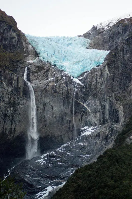
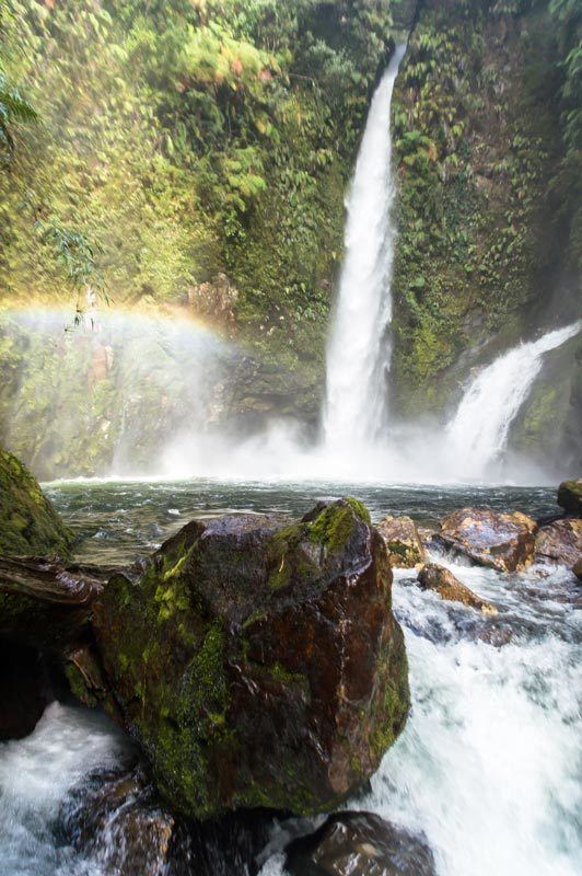
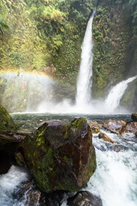
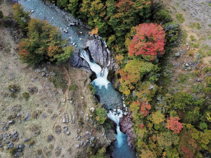
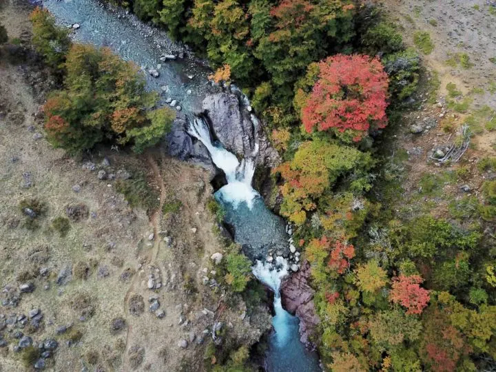
Puyuhuapi and Parque Nacional Queulat: Ventisquero Colgante (Hanging Glacier)
- Distance south of Puerto Montt: 428 kilometers
- Distance north of Coyhaique: 233 kilometers
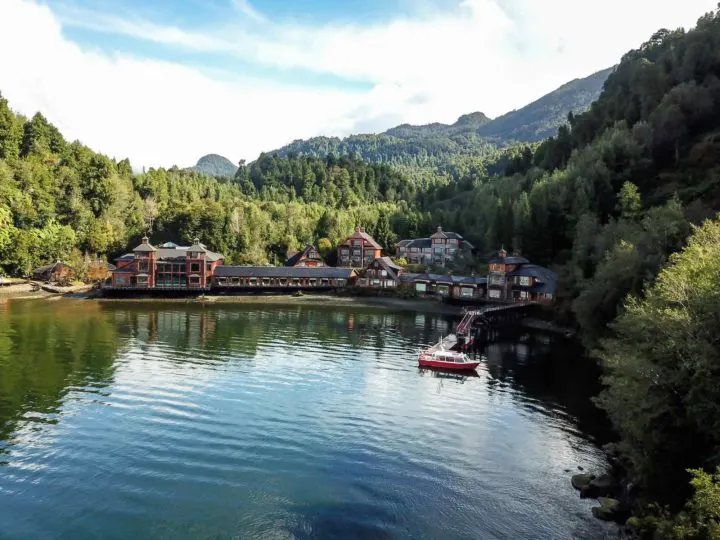
One of the highlights of the northern Carretera Austral is Puyuhuapi. This fjord side town, normally shrouded in equal parts mist and wood smoke from the burners that heat the locals’ homes, feels as remote and Patagonian as they come.
What you’ll quickly notice, however, is both German architecture and language here – a legacy of the German settlers who colonized the area back in the 1930s.
If hanging glaciers and splendid lagoons are your thing, then Queulat National Park ($8,500 CLP ($10 USD)) deserves a day of your time. Within striking distance of the town, this national park is crowned by the Ventisquero Colgante (the Queulat Hanging Glacier).
It’s best appreciated from a spectacular viewpoint, reached by the short path (6.5 km round-trip, 2.5 hours, medium) that begins at the park entrance.

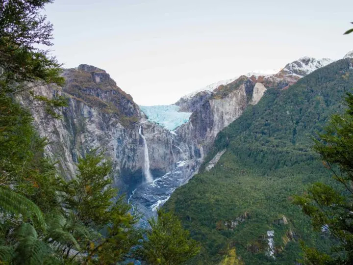
Although it’s a good distance from the glacier, the platform at the end of the 30-minute climb (which is mostly ascent but still a fairly comfortable walk) does have excellent views. Watch the ice calving from the glacier and the two glacier-fed waterfalls which drop 600 meters onto the rocks below, before washing into the lagoon.
The other walks around the park aren’t much to write home about, so a day here is sufficient. You can camp in the official park campsite ($10.000 CLP ($12,10 USD) pp), which is run by Turismo Experiencia Austral and from where all trailheads begin.*
Hitchhiking to the park from Puyuhuapi is a possibility and a minibus (also operated by Turismo Experiencia Austral) leaves Puyuhuapi at 8.30am daily and returns from the park at 6.30pm.
Where to stay in Puyuhuapi
Where to treat yourself in Puyuhuapi: For a treat and the opportunity to soak weary limbs, take a few days to spend in the astonishingly beautiful Puyuhuapi Lodge & Spa ($202,000 CLP-$538,000 CLP ($278 USD-$740 USD) double).
Where to stay on a budget in Puyuhuapi: For those self-catering, Hostal Aonikenk ($44,000 CLP ($61 USD) double) is a great option, thanks to a communal kitchen. The best rooms here are the newest ones, which are spacious and have electric, rather than paraffin, heaters.

It’s accessible only by speedboat and it’s likely you’ll spot a dolphin from your bedroom window. The star attractions are the three outdoor thermal pools, which have stunning views across the fjords toward the national park.
Getting to Puyuhuapi
Coyhaique
- Distance south of Puerto Montt: 661 kilometers
The best place to stock up on food along the Carretera Austral (as most of the other towns and villages, only offer the very basics), Coyhaique is a charming but smoky Patagonian town – which regularly tops the pollution index for Chile.
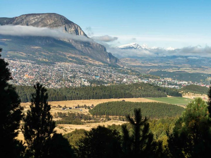

With free wifi in the main square, and delicious restaurants such as Mama Gaucha, it’s easy to understand why I always end up spending longer here than planned.
Aside from the relative comfort of its facilities, there’s not an awful lot to do here. It’s the main transport hub, connecting destinations in the north and south and most will pass through after landing at nearby Aerodromo Balmaceda or sailing into port at Puerto Chacabuco, while it’s an inevitable stop if you’re covering at least half of the Carretera Austral.
If you do end up spending a day or three here, I would recommend a day trip out to Coyhaique National Reserve (Reserva Nacional Coyhaique; $3,000 CLP ($4 USD)), which lies five kilometers north of the town.
Well-marked trails (ranging from an hour’s hiking up to seven) and glorious views of Coyhaique and the deep valley in which it sits make the reserve a fantastic destination.
Full information about the trails and a map of the park is available at the entrance (or to download here). You can get here by hiking (it’s steep!), taxi, or hitchhiking (although the latter is hard to do because the entrance is up a side road.
Where to stay in Coyhaique
Where to stay in Coyhaique: You won’t get more attentive service than at the modern Raices Bed and Breakfast ($82,000-92,000 CLP ($113-$127 USD) double), where 12 large bedrooms have access to cozy communal areas and an outdoor terrace. Bilingual owner Cecilia is on hand to offer information and can organize regional tours.
Where to stay in Coyhaique on a budget: Attracting backpackers and budget-minded travelers, Esquina Patagonica ($58,000 CLP ($62 USD) double) has sizeable rooms and a mix of doubles, singles, and triples with private bathrooms; avoid the cheapest double with bathroom if you want to have space for your suitcase. Added extras include guest kitchen access, laundry service, and parking, while a big breakfast is included in the price. English is spoken.
Getting to Coyhaique
Villa Cerro Castillo and Parque Nacional Cerro Castillo
- Distance south of Puerto Montt: 757 kilometers
- Distance south of Coyhaique: 98 kilometers
Lying between Puerto Río Tranquilo and Coyhaique, Villa Cerro Castillo is home to its namesake national park, Cerro Castillo ($4,000-$10,000 CLP ($6-$14 USD) depending on the section of the park). Before I visited, I’d heard many rave about this park, ranking it among their favorite places in all of Patagonia.
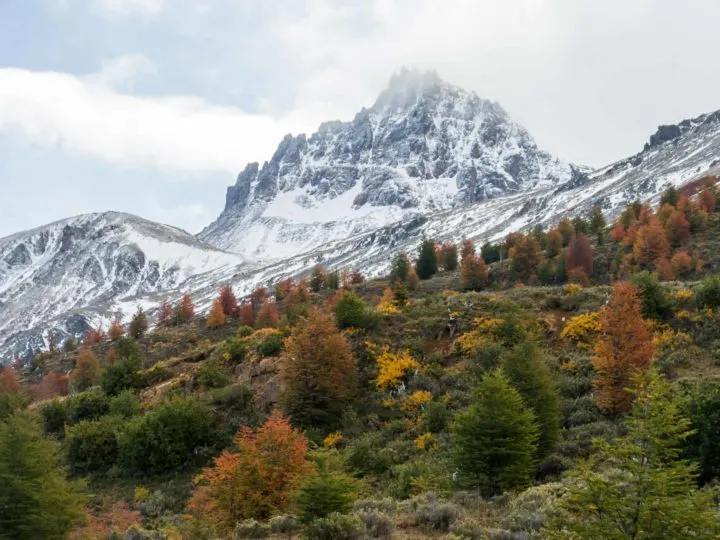
The main attraction is Cerro Castillo, which, thanks to its three pronged-peak has been compared to Torres del Paine in Southern Patagonia. I’ll admit that this mountain isn’t quite as picturesque, but it’s certainly a spectacular national park and – best of all – frequented by far fewer visitors.
Hiking here is also fantastic for spotting huemules (the endangered south Andean deer) and other native wildlife.
There are two main trails: The most popular is the steep, 14-kilometre, six-eight-hour hike up the Sendero Mirador Laguna Cerro Castillo to Lago Cerro Castillo (which sits beneath the peak). The trailhead is five kilometers northwest of the village.
The second is the four/five-day, 51-kilometer hiking circuit known as the Cerro Castillo Traverse or the Travesía Las Horquetas. The latter is a challenging trek through a series exposed of exposed mountain passes with panoramic views of glacier-studded peaks.
Only those with trekking experience and camping equipment suitable for cold and wet weather should attempt this alone and poor weather can close the trails – you can check conditions using Mountain Forecast. November through April are the best months for hiking; outside of these months, you’re required to request permission from CONAF before attempting any of the treks.
The best website for English-language information about this longer circuit is this one, written and updated by Villa Cerro Castillo locals.
Where to stay in Villa Cerro Castillo
Where to stay in Villa Cerro Castillo: Set down a track on the southeastern edge of the village, La Araucaria ($4,000 CLP ($6 USD) camping, $10,000 CLP ($14 USD), $50,000 CLP ($70 USD) 4-person cabin or 2-person dome) has everything from a large, grassy camping area to domes with dormitory beds (but no heating), a two-bed dome with private bathroom and gas heater, and four self-sufficient cabins for four people, with kitchens.
Where to stay in Villa Cerro Castillo on a budget: Accommodation is very, very basic at mountain refuge-style Senderos Patagonia ($5,000 ($7 USD) camping, $10,000 CLP ($14 USD) dorm). It attracts backpackers and hikers, making it a good place to swap notes on local trails with fellow travelers, particularly in the expansive kitchen. The dorms are large and bed linen is charged at an additional $2,000 CLP ($3 USD. The Spanish- and English-speaking owners run high-end horse riding and trekking excursions in the national park and farther afield.
Getting to Villa Cerro Castillo
All buses heading north and south pass through Villa Cerro Castillo; the bus stop is on the main road that slices through the village.
Puerto Río Tranquilo and Las Cavernas Marmoles
- Distance south of Puerto Montt: 877 kilometers
- Distance south of Coyhaique: 216 kilometers
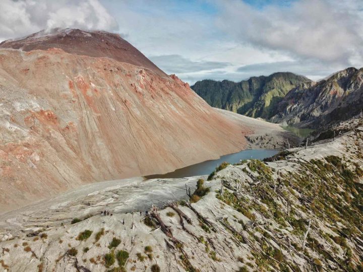
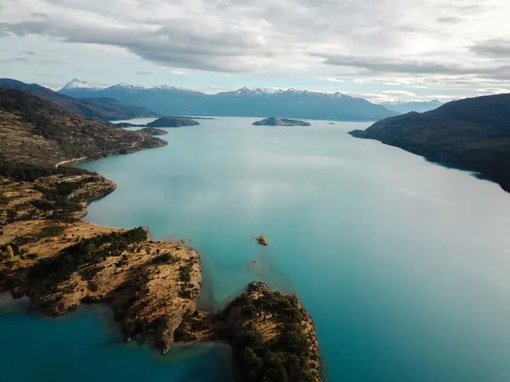
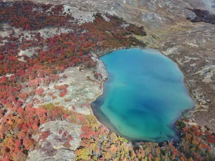
When I first visited the Carretera Austral, the destination top of on my itinerary was Puerto Río Tranquilo. There are few other places quite like it in Patagonia: the incredible Marble Caves, whose swirling patterns of blue, grey, and black marble against the glacial blue of Lago General Carrera must be seen to be believed.
What’s more, the journey along the shoreline of the lake to reach Puerto Río Tranquilo is truly fantastical.
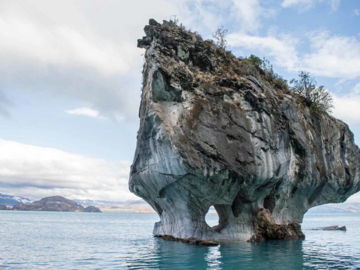
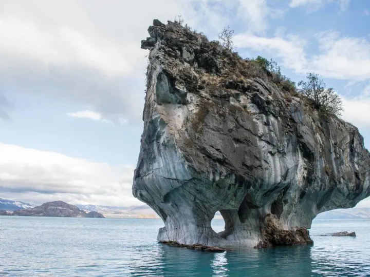
Luckily, it’s easy enough to visit. You can book a speedboat tour (1.5 hours) from the harbor in Puerto Río Tranquilo for just $20,000 CLP ($22 USD). Aim to take a tour in the early morning for the best lighting – although this isn’t as easy as you might think, as departures depend on weather conditions and the waves in the lake can be fierce.
For an additional $10,000 CLP ($11 USD), you can extend your tour to a three-hour trip that goes across the lake to Puerto Sánchez, where there are further spectacular caves that are even more accessible by boat and fewer tourists.
If you’re feeling more energetic, you can also kayak to the caves for $50,000 CLP ($55 USD), although only when the water is calm. Local outfits such as Valle Leones are a good choice.

Tourists willing to part with a lot of money can also visit the nearby 30-meter-high Ventisquero San Rafael (San Rafael Hanging Glacier), in San Rafael National Park. Retreating at an alarming rate, it’s worth a visit to watch the ice calving off the glacier and into the sea, particularly seeing as scientists warn it could disappear by 2030.
Found my advice helpful and want to say thanks?
Destino Patagonia Exploradores in the village can set you up on a one- or two-day tour (starting from $190,000 CLP ($205 USD)) on a small vessel, including a drink of whisky with shaved glacial ice. Cheers!
Another option is ice trekking on Glaciar Exploradores. However, the glacier has retreated significantly, and the glacier is currently closed because hiking tours have caused so much damage, that it’s no longer an activity I feel comfortable recommending.

Where to stay in Puerto Río Tranquilo
As a one-horse town that occupies a small stretch of land along the skirts of Lago General Carrera, there isn’t a tonne of options when it comes to accommodation.
Where to stay in Puerto Río Tranquilo: My favorite option, but only for those with their own wheels as the lodge is 48 kilometers south of Puerto Río Tranquilo (an hour-or-so drive), is to stay at lovely Mallin Colorado Ecolodge ($101,000 CLP ($139 USD) double, $158,000 CLP ($216 USD) two-person cabin). All of the rooms have floor-to-ceiling windows with striking views across Lago General Carrera. Meals are available on request, as are horseback riding tours and hikes around their extensive grounds, while the staff and owners are wonderful. You can read all about my stay at Mallin Colorado Ecolodge.
Where to stay in Puerto Río Tranquilo on a budget: Hospedaje y Camping Bellavista ($5,000 CLP ($7 USD) camping, $12,000 CLP ($16.5 USD) dorm, $25,000 CLP ($34 USD) double) is both comfortable and friendly, with private bedrooms in their chipboard guesthouse and a huge field for campers. Kitchen access and hot showers are included.
Getting to Puerto Río Tranquillo
Chile Chico and Parque Nacional Patagonia
- Distance south of Puerto Montt: 814 kilometers
- Distance south of Coyhaique: 154 kilometers
Lying on the southeastern shore of the ultramarine Lago General Carrera, Chile Chico bathes in an unusually sunny and dry microclimate. Bizarrely, this part of the Carretera Austral cultivates cherries and is home to five endemic species of cactus – the latter of which are considered the southernmost in the country.
But besides the town’s favorable weather, Chile Chico is mostly a transition point for travelers either leaving the Carretera Austral for Argentina or for those coming in the opposite direction.
Beyond this, it’s the gateway to the barely-visited Sector Jeinimeni ($3,000 CLP ($4 USD)) of Patagonia National Park, about which little has been written.
I’ve personally never been, but I’ve heard that there is some pretty hiking through a privileged landscape of milky-hued lakes, glacial-scoured mountain peaks, and rolling expanses of the rough-edged Patagonian steppe.
The best place to find information about this sector of the park is via the Ruta de los Parques official website, which has hiking trails and camping information.
You’ll need to scroll down past the trails in the Valle Chacabuco section of the national park to reach those pertaining to Jeinimeni, which start from “Piedra Clavada, Cuevas de las Manos, Valle Lunar Trail”). You can also download a map of the park here.
Where to stay in Chile Chico
Where to stay in Chile Chico: My favorite accommodation in town is the intimate and charming Hostería de la Patagonia ($5,000 CLP $7 USD) camping, $74,380 CLP ($90 USD) double), situated on the far eastern edge of the town, close to the Argentine border. Their most unique lodgings are their boat room – literally a converted boat that used to sail on the lake.
Where to stay in Chile Chico on a budget: Posada de la Luna ($55,000 CLP ($60 USD) double with shared bathroom) is known for its welcoming and cozy atmosphere, and provides a great base for those exploring the area. Guests also have access to the shared kitchen and a shared lounge.
Getting to Chile Chico
Cochrane and Parque Nacional Patagonia
- Distance south of Puerto Montt: 991 kilometers
- Distance south of Coyhaique: 330 kilometers
An hour’s drive south of Lago General Carrera, Cochrane is Patagonia’s next big adventure destination. It makes me think of what El Chaltén must have been like before the tourists arrived, with its laid-back vibe and wealth of adventure pursuits literally at your fingertips.

The finest is undoubtedly Patagonia National Park, the second of Doug Tompkins’ great legacies to the Carretera Austral.
The southern two sectors of the park, Valle Chacabuco (free) and Tamango ($5,000 CLP ($7 USD)) are home to varied ecosystems, from arid steppe to low mountains populated with southern beech forests. Beyond this truly spellbinding scenery is a wealth of excellent and well-marked hiking trails.
In Valle Chacabuco, my personal favorite was the Lagunas Altas trail (23-km loop, 6-8 hours, medium), which climbs up into the mountains for viewpoints across pristine lagoons and the valley that contains much of the park.

There are a handful of other short day hikes but you really need a car to get here (hitchhiking is possible – I did it – but can take a long time) and also for driving between the trailheads, which are spread out across a large area.
You can camp in the pretty Los West Winds Campground (at the trailhead for Lagunas Altas) or at one of the other campgrounds; information about all of the hikes is on the Ruta de los Parques website (English). You should also be able to pick up maps from the visitors’ center when you arrive at the park. There’s also an excellent guide to hiking in the park here.
A far more accessible part of the national park is Sector Tamango, which is situated just a few kilometers northeast of Cochrane.
There are around ten trails here, ranging from one-hour through ten and the most picturesque parts of the national park are those lining the pristine waters of Lago Cochrane, while the forests are inhabited by a small population of the critically endangered huemul.
You can find a map of the trails in this section of the park here.
Where to stay in Cochrane
Where to stay in Cochrane: The most hotel-esq is the utilitarian in style Ultimo Paraiso ($86,000 CLP double). Rooms feel a bit gloomy, but have large, modern bathroom suits and wood burners to keep them warm and do represent a cut above the other options in Cochrane. They can organize day tours to fly fish on local rivers and lakes.
Where to stay in Cochrane on a budget: A little smarter and larger than most options in town is Lejana Patagonia ($30,000 CLP ($41 USD) double), with decent-sized bedrooms and kitchen access, although the whole building is made of wood so noise between the rooms can be an issue.
Getting to Cochrane
Caleta Tortel
- Distance south of Puerto Montt: 1,116 kilometers
- Distance south of Coyhaique: 455 kilometers
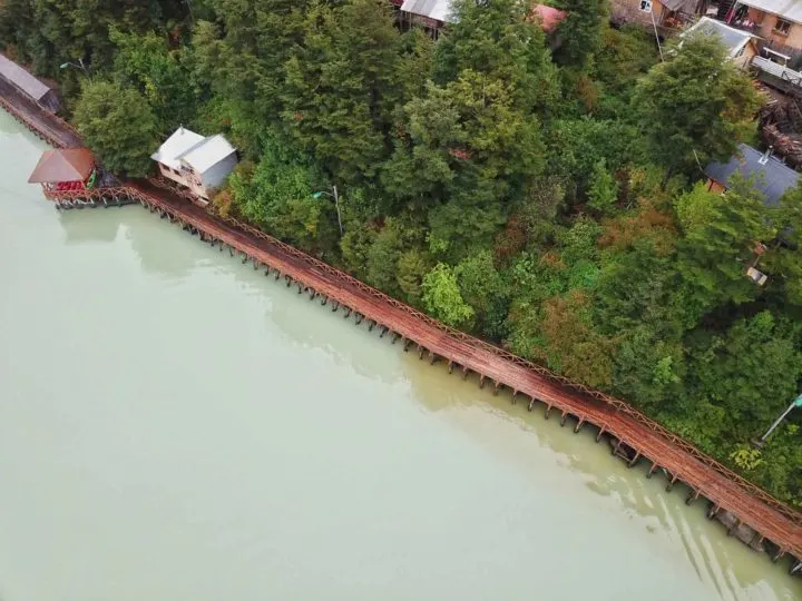
Nothing really prepares you for the sight of Caleta Tortel, officially the Carretera Austral’s most quirky town. Clinging to the forested edges of a small hill and overlooking the milk-blue waters of the sound below, this settlement is unique in that it contains not a single road.

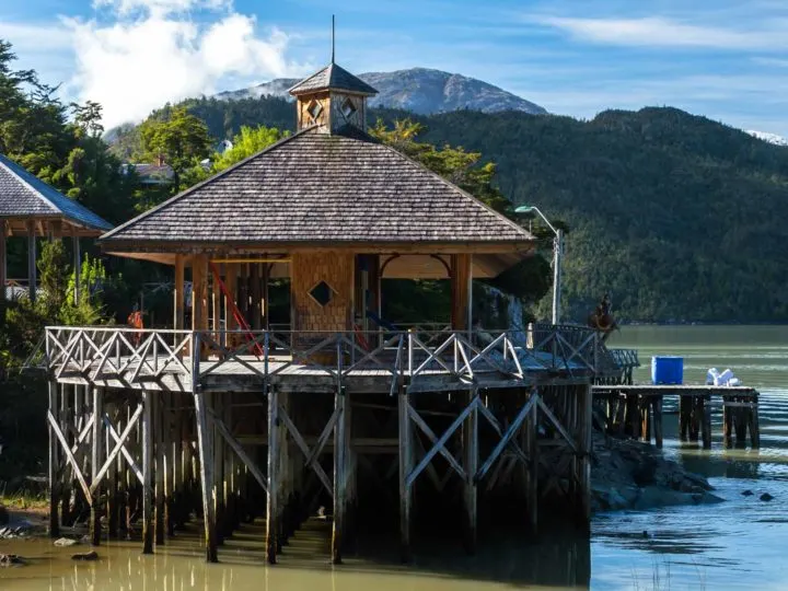
Instead, wooden boardwalks provide access from one side to the other. It’s truly magnificent in the sunshine when the sun casts the place into relief and you can wander along the pathways practically hovering above the water.
Beyond its picturesque aspect, the town also has access to a handful of glaciers, Ventisquero Steffens and Jorge Montt.
You can visit by boat tour with one of the local people – expect to pay from $70,000 CLP ($96 USD) and tours only leave when there are eight passengers, so it can be difficult to organize one outside of January and February.

You can also arrange kayak excursions or take a short boat tour out to the bleak Isla de los Muertos, an island shrouded in infamy. It’s where the 33 pioneering settlers of Caleta Tortel were buried – having been poisoned by their employer, or so the locals claim. The trip costs $40,000 CLP ($55 USD) per boat, with space for four passengers.
Where to stay in Caleta Tortel
Caleta Tortel is larger than it looks and it can take a long time to walk from its northern to its southern edges. All buses heading out of the town leave from the Estacionamiento (the parking lot) where all vehicles must be parked.

Where to stay in Caleta Tortel: Caleta Tortel’s most comfortable option is Entrehielos Lodge ($103,000 ($142 USD) double). It has five modern bedrooms, central heating, a pretty sitting room with views across the fjords and a dining room where you can request delicious Chilean meals. They also can sort you out with tours of the glaciers and the surrounding area.
Where to stay in Caleta Tortel on a Budget: Hostal Natureza is a real home-from-home and a hit with guests. Expect comfortable beds, a cozy atmosphere, and hearty breakfasts. Email [email protected] or call +56951427329 to book.
Getting to Caleta Tortel
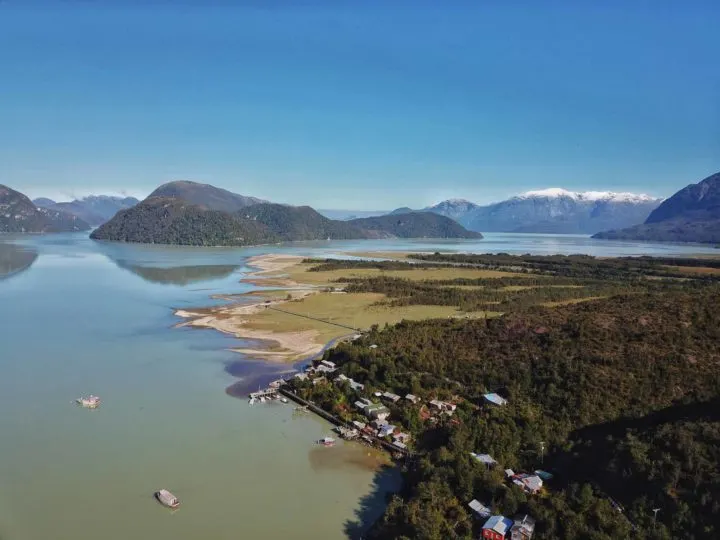
Villa O’Higgins
- Distance south of Puerto Montt: 1,224 kilometers
- Distance south of Coyhaique: 563 kilometers
The time you reach Villa O’Higgins, you truly begin to appreciate quite how wild this corner of Patagonia really is. There’s a reason that this tiny town didn’t have road access until 1999 – and it doesn’t really feel any more accessible now that it does.

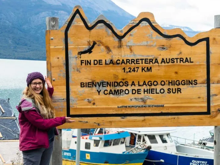
Ringed by dramatic mountains on two sides and set on a flat plain in the valley floor, Villa O’Higgins still feels owned by the landscapes onto which man has encroached. It’s also the official end of the Carretera Austral.
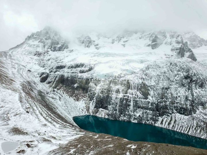
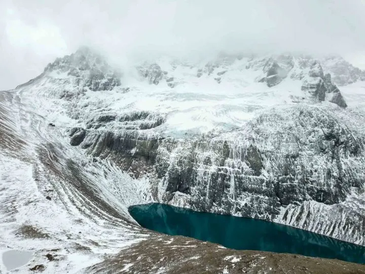
The biggest draw here is the access to the Southern Patagonian Ice Field, which lies south of the town. The most accessible glacier in this range is Glacier O’Higgins, whose cobalt face of ice can be watched crashing into the gleaming waters of its namesake lake from aboard a sailboat.
However, the pandemic caused real damage to the tourism industry here and excursions to the glacier are now limited. These excursions used to be operated by a local tour company, Ruedas de la Patagonia, who charge CH$170,000 ($180 USD) for a seven-hour tour up to the glacier’s snout.
Where to stay in Villa O’Higgins
Where to stay in Villa O’Higgins: For cozy cabins and comfortable yurts with their own private hot tubs, check out Entre Patagones ($40,000 CLP ($55 USD)- $50,000 CLP ($67 USD) 2-person cabin, $65,000 CLP ($90 USD) yurt). Their two modern yurts are the most comfortable, hidden away in the forest, and they have a fully equipped kitchen.
Where to stay in Villa O’Higgins: The most luxurious choice in town is Rumbo Sur ($166,000 CLP ($228 USD) double). Stylish bedrooms, access to hot tubs looking west across the mountains, and a beautiful clubhouse heated by a welcoming wood-burning stove make this the ultimate place to relax in Villa O’Higgins. I thoroughly enjoyed staying here and the staff have excellent knowledge of the region and its activities.
Where to stay in Villa O’Higgins on a budget: A meeting place for backpackers, cyclists, and road trippers, El Mosco ($6,000 CLP ($8 USD) camping, $12,000 CLP ($17 USD) dorm, $45,000 CLP ($62 USD) cabin or double) is basic but affordable and very sociable. Dorms and private doubles have access to a large kitchen with attached living area on the ground floor; for more space, opt for a cabin, which has its own private kitchen and bathroom. The staff are very knowledgeable about activities in the region and the border crossing to El Chaltén. Please note: El Mosco was closed for the 24/25 season, and we’re waiting to see if they will reopen for the 25/26 season.
Getting to Villa O’Higgins
How to explore the Carretera Austral: a Patagonian road trip, bus-to-bus or hitchhiking
The Carretera Austral is the perfect place for a journey and there are plenty of different ways to approach this road.
For those with larger budgets, a rental car is the ideal means; for those on smaller budgets, buses can help you hop between the different towns. Hitchhiking – if you’ve got plenty of time and patience – is another rewarding choice.
You can get plenty more information in my guide to car hire for the Carretera Austral and Patagonia.
Where to hire a rental car in Patagonia
As a prime spot for a Patagonia road trip, the Carretera Austral is approached by many via car, as you can traverse the whole route at a leisurely pace and enjoy its various ferry crossings.
In the north: Aeropuerto Internaciónal El Tepual, the airport just outside of Puerto Montt, has some of the cheapest car rentals I’ve found in Chile, with rental rates starting from $33,000 CLP ($35 USD) per day.
You can book through Rental Cars, a comparison and booking site I’ve used on numerous occasions, however, some of the companies do not allow you to drive on the Carretera Austral or take ferries with your vehicle. Therefore, either check the terms and conditions of the booking thoroughly or book through Econorent, who definitely do allow you to take a vehicle on the Carretera Austral.
Along the Carretera Austral: Another option is from Aerodromo Balmaceda. Prices are higher than in Puerto Montt and you can expect to pay at least $371,000 CLP ($400 USD) for a week’s rental.
International companies such as Europcar operate here, but overcharge and provide poor customer service. However, if you want the security of booking through a global company, then they are a good choice. You can check up-to-date prices with Rental Cars, the company I use when hiring cars in Chile.
Local companies can offer better service. For example, Patagonia Rent (tel. 9/3930 3011 has a booth at the airport, while companies such as RecaSur, Ruta 7 Rent a Car (Los Claveles 1206, tel. 9/3459 1165) and Ñirehuao Rental Sur (Portales 256, tel. 9/8754 1497) often have availability and doesn’t necessarily show in Rental Cars’ database.

In the south: The cheapest place to pick up a rental vehicle is in Punta Arenas, although there are also rental companies in Puerto Natales.
From my experience, prices are cheaper if you rent from the Chilean side rather than the Argentine side of Patagonia, but it’s worth shopping around.
Know-before-you-go: Hiring a car for the Carretera Austral
Where to hire a campervan for the Carretera Austral
Hiring a campervan for the Carretera Austral is also very popular – particularly as it allows you to stop as and when you wish along your journey.
In the north: The best place to pick up your new wheels is from Puerto Varas (a 30-minute drive northeast of Puerto Montt) with Ruka Motors or Wicked Campers.
Expect to pay $994,000 CLP ($1069 USD) for a one-week rental in peak season. Prices will be significantly higher if you rent from one destination and return to another.
Along the Carretera Austral: You can also pick one up in Coyhaique from Recasur. Prices will likely be higher here because of lack of competition, however, if you’re struggling to find a hire car on Rental Cars, RecaSur often have vehicles to rent.
In the south: Punta Arenas has a number of rental agencies; Andes Campers, Wicked Campers and Holiday Rent have depots here. Expect to pay $916,000 CLP ($985 USD) for a one-week rental in peak season.
Top tips for a road trip along the Carretera Austral
The Carretera Austral is widely considered Patagonia’s finest road trip. Part of the appeal is how beautiful the landscapes are and the fact that, with your own transport, you can stop practically anywhere you wish for a photograph, for a picnic, or even to camp overnight.
Struggling to plan your Carretera Austral road trip?
Get the expert (me!) to help you plan the perfect route down this famed road. I’ll give you helpful guidance to help you decide where to go, plus logistical information, accommodation, tour recommendations, and that all-important local knowledge you need to have an unforgettable trip.
Learn more about my trip planning calls here.
Want someone to do all the legwork? EcoChile Travel, one of my recommended partners in the area, offers an incredible 19-day self-drive tour of the Carretera Austral. Combining a range of guided and self-guided excursions, it’s perfect if you want someone else to deal with the logistics of your tip and means there’s always someone on the other end of the phone to help with breakdowns, accidents, or anything else en-route.
Get a 5% discount on this trip by mentioning Worldly Adventurer when you book.


As a route in constant construction and facing less-than-predictable weather, it’s essential to be well-prepared before you set off:
- Allow yourself a flexible itinerary. In Patagonia, things don’t always go quite to plan.
- Two weeks is enough time to drive, and enjoy, most of the Carretera Austral; three weeks is even better. However, because of the prohibitively high costs of one-way rentals, it makes financial sense to hire and drop off your vehicle in the same place. As a result, you could start in Puerto Montt and head south to Puerto Río Tranquilo, before turning around and driving back to Puerto Montt. Alternatively, fly into Balmaceda (where you can rent a car using Rental Cars) and head north to Puyuhuapi, south back down to Caleta Tortel, with plenty of time to explore the attractions en route, before returning to Balmaceda to drop the car. If you’re keen on seeing those within striking distance of Coyhaique, a week is enough to drive up north to and from Puyuhuapi and south to and from Cochrane, both of which are a day’s drive.
- A 4WD vehicle is not essential but a high-clearance vehicle and patience are indispensable.
- Around 90% of the road from Puerto Montt to Puyuhuapi is now paved. South of Puyuhuapi, you’ll encounter gravel roads and plenty of construction projects This portion is less pleasant to drive, but the scenery and the feeling of remoteness are incomparable. Road construction on the stretches directly south of Puyuhuapi, Coyhaique, and Villa Cerro Castillo, can add up to an hour of driving time and 1pm through 5pm is peak time for road closures. You can check for this information in the tourist information offices in Puerto Montt or Coyhaique.
- You can find updates on the state of the roads by searching on the Via Austral website (Spanish).
- The most up-to-date information about the different border crossings along the Carretera Austral is typically available on iOverlander. You can download it as an app.
- Avoid driving faster than 60 kilometers per hour. Possible hazards include tire punctures, chips to the windshield from gravel, and unexpected wildlife on the road. Make sure you have insurance that covers your windshield, as it can be expensive if it cracks. Pack food, water, and a sleeping bag in case of breakdowns and be aware that many basic insurance policies don’t cover you for breakdowns; pay for additional coverage, otherwise you will have to cover the cost of towing the vehicle. When picking up your vehicle, double-check it has its spare tire – you may well want it!
- Pack food, water, and a sleeping bag in case of breakdowns. When picking up your vehicle, double-check it has its spare tire – you may well want it!
- Fill up with fuel every time you see a gas station. While there are now plenty of gas stations along the Carretera Austral, the rule of thumb is to fill up whenever you see one.
- Pick up a copy of the COPEC Rutas de Chile map. This map of all of Chile and Argentine Patagonia is indispensable for anyone driving in Patagonia. You can theoretically pick it up from any COPEC gas station for around $3,000 CLP ($4 USD) – in practice, many places don’t stock it, so you may need to visit a couple. It has all COPEC gas stations marked on it; as the most frequent of all the companies selling fuel in Chile, this is useful stuff. They don’t have Argentine fuel stations marked, however.
- Download Organic Maps before you set off. This free app allows you to download maps of the Carretera Austral to your phone (do this while you still have a wifi connection!) that can then be used offline. Their maps use OpenStreetMap data so generally have accurate hiking trails marked on them.
- Download the ioverlander app. This free app is a crowd-sourced guide to road conditions and campsites as compiled by overlanders (people who travel overland). It is an indispensable resource for helping you to find good wild camping spots, as well as up-to-date information about the state of the Carretera Austral. You do need internet to be able to access the maps in the app.
- Wild camping is generally permissible. In most cases, you can pitch up practically wherever you want along the Carretera Austral, although ioverlander should give you a good sense of where you can’t and where it’s recommendable to stay. Practice leaving no trace principles and make sure that whatever rubbish you bring in you take out with you. If the land is clearly privately owned and there’s a dwelling nearby, be sure to pop in and ask for permission before settling down for the night.
- That said, there are some lovely hotels along the route. I’ve pulled together my favorite places to stay along the Carretera Austral and Chile more generally – it’s worth a read!
- Make sure your normal sim card works or pick up a local pay-as-you-go sim card. If you plan on booking accommodations and doing other logistical stuff en route, don’t expect to be able to rely on the internet along the Carretera Austral. The internet reception through my phone is invariably faster than what you can pick up through WIFI at most hotels and hostels, so do yourself a favor and sort this before you get to Patagonia. Along the Carretera Austral, Entel has the most coverage (Claro comes in second) and can be picked up from booths manned by these companies in big shopping malls in cities such as Santiago or even in some corner shops. You top it up in pharmacies (don’t ask me why!) or more easily by downloading the company’s app onto your cell.
- The Carretera Austral is still in the process of being asphalted. Note that road works can cause sections of the road to be closed, normally between 2pm and 5pm during the day. This information is best found by consulting the tourism office of the town you’re in and then planning accordingly.
- Consider picking up hitchhikers. The vast majority are your fellow travelers just looking for a kind stranger to give them a ride. They’ll be ever so grateful if you do!
- Get additional insurance if you’re crossing into Argentina at any point. See the rental car section in this article for further information.
- Make sure your car insurance covers transit along the Carretera Austral. I had a company in Coyhaique who tried to rent me a vehicle but said it wasn’t covered for the road. Go figure.
Top tips for taking the buses along the Carretera Austral
As it’s regularly cited as one of Patagonia’s finest road trips, it certainly feels like a bit of a shame not to drive the Carretera Austral. However, if you have a limited budget, this may well not be a possibility.
Luckily, the bus system has become far more robust and reliable over the past few years and you can generally find daily departures for most destinations along the Carretera Austral.
I’ve included bus timetables throughout this article, although these change frequently, so do not rely on them! Further tips are:
- Some companies are starting to list their timetables and allow you to purchase tickets on Kupos.cl. This is the minority, not the rule, but does mean you can occasionally book buses in advance rather than at the bus station.
- Always book your bus at least a day in advance. If traveling the longer, less frequent routes such as Chaitén to Coyhaique, book as soon as you get to whichever of the towns you’ll be departing from. Tickets can run out, particularly in January and February.
- Take snacks and plenty of water. Distances are far and journeys can take a long time. Unlike most of South America where you can expect to be offered food from vendors by the side of roads on a regular basis, places where you can pick up food and few and far between along the Carretera Austral.
- Don’t expect luxury – or toilets. For longer-distance rides (such as Coyhaique to Chaitén), the bus will stop for lunch and a toilet stop halfway along the journey. For middle-distance rides (such as Coyhaique to Cochrane), you may get a toilet break in Puerto Río Tranquilo, but otherwise, you’re in it for the long haul and there aren’t toilets on the buses, which are typically small buses rather than larger coaches.
Top tips for hitchhiking along the Carretera Austral
Hitchhiking or going a dedo is a popular way for backpackers to travel along the Carretera Austral.
Not only is it cheaper (local buses can be expensive) but it’s a great way of meeting some of the local people, who are generally very open to giving a lift to friendly travelers.

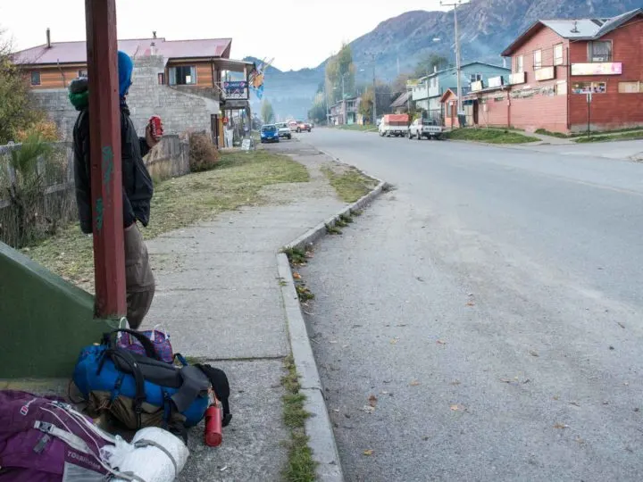
I’ve personally hitchhiked a couple of stretches of the Carretera Austral (including from Coyhaique to Puyuhapi, which we managed by sheer serendipity) and would recommend the following:
- Competition for rides is fierce, particularly in January and February. You can expect to spend hours waiting for a lift – so start early to get out onto the road before other hitchhikers. Be persistent and someone will pick you up.
- Couples and individuals are significantly more likely to get picked up than larger groups.
- A lift for a short distance is far easier than for a longer one. This should hopefully be obvious, but finding a vehicle that’s going from Coyhaique all the way through to Chaitén is highly unlikely. Expect to travel to the next town or two with each ride.
- Hitchhiking solo is safe. Or at least has been in my own experience. Use your judgment and your gut feeling and read these tips for staying safe hitchhiking in South America.
- Drivers don’t expect payment but they do expect conversation. If you get picked up, the deal is you chat to the driver. If you don’t speak any Spanish, learn some – it’ll enrich your experience and be a welcome reprieve from the quietness of the drive for the driver.
- Taking a tent and plenty of food with you is a sensible idea when you hitchhike. As you never quite know where you’ll end up, it’s a good idea to have your own accommodation at hand in case you do end up stranded in the middle of nowhere.
For more information about the different means of getting into Patagonia (think plane, bus, car, and ferry), read this logistical dream of an article: Getting to Chilean and Argentine Patagonia (both north and south).
Equipment to take for a Patagonia road trip along the Carretera Austral
The Carretera Austral is known for its five-star hiking, including the breathtakingly wild landscapes of the dozen or so national parks found within its environs. Because of this, you’ll want hiking clothing and equipment to keep you both comfortable and safe on the trail.
In general, you’ll want to pack:
- Sturdy hiking shoes: I love my Salomons (for women: REI|Backcountry|Amazon / for men: REI | Backcountry| Amazon)
- A waterproof raincoat: I love Patagonia Jackets as they tend to be ultralight, easy to pack but fully waterproof (for women: Patagonia / for men: (REI|Backcountry|Patagonia); the North Face Alta Vista (for women: Amazon|REI / for men: Amazon|REI) is a good shout for a more affordable choice. I’ve also heard great things about Arc’teryx (REI|Amazon) too.
- Warm outer layers for the night: A warm fleece (for women: REI |Backcountry|Amazon / for men: REI|Backcountry|Amazon) or a down jacket are versatile items that should keep you cozy and warm. I love my new Jack Wolfskin down jacket (Amazon). The North Face has some good synthetic down jackets (REI|Backcountry|Amazon), while Mountain Hardwear has some water-repellent down jackets (REI|Backcountry|Amazon)
- Clothing that can be layered: Items that can be layered up in cold weather and stripped down in warm weather are versatile for any temperature.
- A water bottle and water filter: Water is potable in Patagonia, however, if you have a sensitive stomach, it’s best to err on the side of caution. A Grayl Geopress (REI|Backcountry|Amazon) or Steripen (REI|Amazon) are my recommendations (read why they’re my favorite portable water filters), while a Nalgene water bottle (REI|Backcountry|Amazon) is a great addition to your bag.
- A power pack: Essential for charging up your cell phone if you’re out hiking and using GPS all day or on a multi-day trek (check them out on Amazon).
- A copy of Moon Chile, my guidebook that covers the Carretera Austral in extensive detail (even more so than this article!). The Bradt Guide to the Carretera Austral has even more detail and is great if you have lots of time along the road as it contains great off-the-beaten-path suggestions.
- Toilet paper: Public toilets are few and far between! Be sure to come prepared instead.
- A local sim card: This is mostly helpful if you’re planning on driving and need to be able to make emergency phone calls. Entel provides the best coverage along the Carretera Austral.
If you plan on camping in any of the national parks or want to wild camp as part of your road trip, I would strongly recommend packing a good quality and light backpacking tent (read this review to find out why I recommend the Big Agnes Copper Spur HV UL2 tent), along with other camping equipment.
In every town and village along the Carretera Austral, you can find a range of accommodations, from camping to hostels and more luxurious options, so this is only for the most adventurous.
- A tent: I strongly recommend the lightweight Big Agnes Copper Spur HV UL2 tent (buy it on REI|Backcountry|Amazon), the North Face Stormbreak 2 (buy it on REI|Backcountry|Amazon or, for a little more space, the North Face Stormbreak 3 (buy it on REI), which has a little more space as it’s a 3-man rather than 2-man tent.
- A sleeping bag: Bear in mind that regardless of the month, it can get very cold in Patagonia at night time. That’s why I recommend either the Rab Ascent Down Sleeping Bag or The North Face Trail Lite Down 0 Sleeping Bag – both are down-filled, and suitable for all four seasons (while still being lightweight!)
- A sleeping pad: Get a cheap foam pad (REI|Backcountry|Amazon ) or a more comfortable Therm-a-rest Prolite (buy it on REI Backcountry|Amazon).
- A cooking stove and gas: The affordable MSR Pocket Rocket 2 (buy it on REI|Backcountry|Amazon) is great value for those on a budget and is super-lightweight.
- Cooking pots: I recommend the MSR pots set (buy them on Backcountry|Amazon).
- Plates, a mug, and cutlery: A collapsible bowl is a great space saver (check out the Sea to Summit on REI|Backcountry|Amazon); I recommend a cheap mug (buy it on REI|Backcountry|Amazon ) and for cutlery, a multipurpose spork is a good choice (check them out on REI|Backcountry|Amazon).
- A headlamp: Useful for midnight toilet visits and early morning starts (buy one on REI|Backcountry|Black Diamond).
I’ve written about everything that I took when I visited Patagonia in 2017 and 2018, so check out this guide to packing for Patagonia to make sure you don’t forget any essential gear.
When is the best time to visit the Carretera Austral?
One of the first things you must learn about Patagonia is how unpredictable the weather always is. The locals joke that there’s really no point in looking at the weather forecast – it’ll likely not be accurate.
However, saying that, the best time to visit the Carretera Austral is between November and April. This period covers the very end of spring, all of summer, and the beginning of fall. It’s when you can expect (but not guarantee!) the driest and warmest weather (between 10˚C (50˚F) and 20˚C (68˚F during January and February) and for all tourist facilities to be open.
However, January and February are the peak months for visitors exploring the Carretera Austral, and hotels – and mountains – can be packed as a result.
I would therefore recommend visiting either in late October/November or March/April (the shoulder seasons) for reduced tourist numbers and still mostly good weather.

Note that May through October sees practically all hotels and tour agencies and many restaurants closed for the season, while roads can become impassable due to rain and even snow and ice.
Other planning recommendations for the Carretera Austral
- If you plan on self-catering, it’s worth stocking up with food in Coyhaique. All of the other towns only sell the very basics – you will particularly struggle to find fresh food. Prices are also significantly elevated outside of Coyhaique.
- Take cash out of any ATM that you come across. ATMs can and do run dry along the Carretera Austral and you may well find that they don’t accept your card. I would stock up with Chilean pesos before reaching the Carretera Austral and also bring plenty of US dollars with you. US dollars are generally accepted throughout Patagonia and will often grant you a tax discount on hotel accommodation and tours if you pay with them. They’re also the easiest currency to exchange at exchange houses. ATMs are currently available in: Chaitén, Futaleufú, Coyhaique, Villa Cerro Castillo, Chile Chico, and Cochrane.
- Take a phrasebook or learn some Spanish before traveling. An increasing number of people speak English; however, not only is it significantly easier to get around if you have some Spanish available, but you’ll get so much more of a warm welcome if you do. Chileans are incredibly friendly and seem to understand traveling much more than other countries I’ve been to, making them even keener to talk to you about your adventures or share their own. Lonely Planet has a great phrasebook specific to Latin American Spanish (which, yes is very different to Spanish from Spain!).
FAQS about visiting the Carretera Austral
Where does the Carretera Austral start and finish?
The Carretera Austral starts in Puerto Montt, a coastal town in the Lakes Region and a two-hour flight south of the Chilean capital, Santiago. From Puerto Montt, Ruta 7 – aka the Carretera Austral or Southern Highway – heads south, sandwiched between Reloncaví Bay in the west and the foothills of the Andes Mountains in the east.
The Carretera Austral covers 1,240 kilometers (770 miles) from Puerto Montt at its northernmost tip to Villa O’Higgins at its southernmost. It is broken twice by the terrain of the fjords, which means you’re required to take a ferry instead. The first time is at Hornopirén, 106 kilometers (66 miles) south of Puerto Montt and the second is at Caleta Yungay to cross the Río Bravo, 98 kilometers (62 miles) north of Villa O’Higgins.
How much time do you need to travel around the Carretera Austral?
Two weeks is enough time to drive, and enjoy, most of the Carretera Austral; three weeks is even better. However, bear in mind that, because one-way rentals cost so much, it makes much more sense to pick up and drop off your rental car from the same place.
With a week or ten days, you can hire a car in Puerto Montt and then head south all the way to Puerto Río Tranquilo (875 kilometers (543 miles) south, before turning around and driving back to Puerto Montt or taking a ferry back from Puerto Chacabuco or Puerto Cisnes to Chiloé Island drive back to Puerto Montt from there.
Alternatively, if you’re keen on seeing destinations within striking distance of Coyhaique, a week is enough to drive up north to and from Puyuhuapi and south to and from Cochrane, both of which are a day’s drive.
Alternatively, with 10 days, two weeks. or more, you can fly into Balmaceda, drive north to Puyuhuapi (289 kilometers (180 miles) and then head back on yourself and continue south all the way to Caleta Tortel (418 kilometers (260 miles) south of Balamceda). Finally, you would drive back to Balmaceda to return your vehicle.
What’s the most beautiful part of the Carretera Austral?
It’s hard to pick the most beautiful part of the Carretera Austral! For me, there are a couple of places: the Queulat Hanging Glacier is perhaps one of the most famous sights along the Carretera Austral and known for its egg-blue hues and the way it seems to cling to the side of the mountain.
Parque Nacional Pumalin Douglas Tomkins, which is home to towering forests and a still-smoking volcano, is high on the list, as is Parque Nacional Patagonia, where you’ll find a variety of hiking trails in a deep, wildlife-rich valley surrounded by snowy peaks. The marble caves are also another beautiful part of the Carretera Austral, with the pastel shades woven through the rock in contrast with the electric blue of Lago General Carrera.
Finally, the cypress walkways that cover the roadless fjord side settlement of Caleta Tortel are also beautiful and truly remarkable, too.
Which places can you visit along the Carretera Austral?
There are numerous places to visit along the Carretera Austral, including a host of brilliant national parks replete with hiking trails, the best of which include Parque Nacional Pumalin Douglas Tomkins, Parque Nacional Patagonia, and Parque Nacional Villa Cerro Castillo.
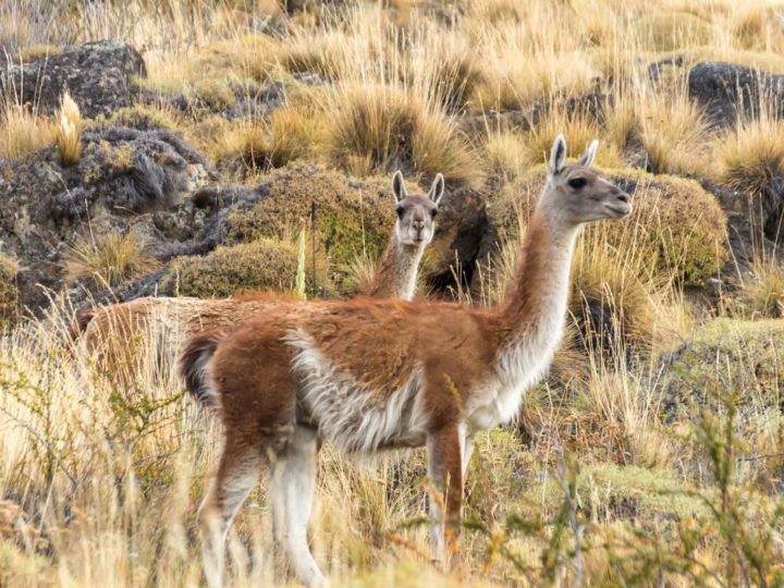
There are also plenty of glaciers you can see and even hike on, beautiful lakes to explore by boat, hot springs for swimming, world-class waters for rafting and kayaking, as well as remote stretches of forest, fjord, and valleys filled with endemic species of deer and birds, herds of guanaco, and even pumas.
Hilve
Saturday 13th of June 2026
Hello Steph! Thank you for your amazing information. Do you know are the ferries etc working in the late Oct. (19.10.-)
Steph Dyson
Thursday 16th of July 2026
Hi Hilve, they will be but with reduced frequencies! Steph
Teresa
Wednesday 4th of March 2026
thanks so much for this detailed and helpful tour ! un abrazo desde Chile
Emily
Thursday 30th of October 2025
Hi, thank you for this incredibly detailed information. I am hoping to travel from Chile Chico to Peurto Montt in a couple of weeks. On buses. I’m trying to check the routes you’ve mentioned, and get times in opposite directions etc, but I can’t find details anywhere but here. I’ve tried the links you’ve given (it won’t let me put in the destinations) as well as busbud and recorrido. We’d love to do this trip but travelling with my child so need to be a bit more secure that things run that I once was! Any advice gratefully received. :-)
Steph Dyson
Tuesday 2nd of December 2025
Hi Emily, sorry for the delay in getting back to you. Unfortunately, bus timetables are incredibly hard to find and change constantly, so it's a bit like whack-a-mole trying to keep them updated. That's why I generally recommend people do the Carretera Austral with a hire car, as it's much more reliable. Steph
Luca
Monday 27th of October 2025
Hi Steph! Congratulations on your writing and the time you've spent writing all this incredibly useful information. Your passion and love for Patagonia shines through. I'm planning my trip, and my dream would be to rent a car in Puerto Montt and leave it in Punta Arenas (I know it would be expensive). Do you have any advice on which car rental company to use? Have you ever heard of LYS Rent a Car? I know it's a middleman between customers and large rental companies, but it has really competitive prices, and I was wondering if it was reliable or not. Thanks for your time if you can answer. Luca
Steph Dyson
Tuesday 2nd of December 2025
Hi Luca, The main thing to be aware of is if they let you drive the car on the Carretera Austral, as some of them don't. I know Econorent does allow you to, but it's a case of checking the terms and the conditions when you book. Steph
Dallas Hewett
Saturday 9th of August 2025
Hi Steph, This is the single most comprehensive overview of the CA I have found! Thank you - amazing. My daughter & I are planning to cycle the CA in December 25' & January 26'. My main issue is getting back to Puerto Montt from Villa O'Higgins at the end of the ride. I am guessing (having read your blog) that bus is the best option? My daughter is going on to Puerto Natales from Villa O'Higgins to do a trek and is also wanting to know the best way? She thinks it is also bus & ferry - any ideas? Thank you again. I can sense the passion you have for this region in your writing! We are very excited to be heading to the CA. Dallas & Sunny - Australia
Steph Dyson
Wednesday 13th of August 2025
Hi Dallas and Sunny, thanks for your kind words! Yes bus is the best way, but it could take you a long time because they're not reliable! To get back to Puerto Montt, my recommendation would to be to get to Balmaceda (you'll have passed it on the way down, it's just south of Coyhaique) and fly from there to Puerto Montt/onwards. That will save you a long time on the bus. The alternative would be to head up to Puerto Cisnes and then take the Naviera Austral ferry from there to Quellon in Chiloe and then head back to Puerto Montt from there (overland and then a very short ferry crossing). I love Chiloe! With regards to getting to Puerto Natales, the boat from Caleta Tortel to Puerto Natales would be the easiest way (and is very beautiful!). It's operated by TABSA. Steph